Mapping Food Deserts in the United States
- by Michele Ver Ploeg, David Nulph and Ryan Williams
- 12/1/2011
Some low-income communities in the United States lack stores that sell healthy and affordable food. The lack of store access in these communities--sometimes called food deserts--may contribute to poor diet, obesity, and other diet-related illness.
The Departments of Agriculture, Treasury, and Health and Human Services (HHS) are bringing together resources and expertise to support sustainable projects and strategies to eliminate food deserts. Private companies, local and Tribal governments, and nonprofit organizations will be able to apply for Federal funds from these three Departments to implement strategies to increase access to healthy, affordable foods.
In support of these efforts, ERS analysts developed the Food Desert Locator--a mapping tool that presents a spatial overview of where food deserts are located and provides selected characteristics of the populations that live in them.
The Food Desert Locator compliments ERS's Food Environment Atlas, which provides county- and state-level statistics on over 100 indicators of food choices, health and well-being, and community characteristics for all counties in the United States.
What Is a Food Desert?
There are many ways to define a food desert or to measure access to food. ERS's Food Desert Locator is based on a definition developed by USDA, Treasury, and HHS. Low-income census tracts with a substantial number or share of residents with low levels of access to retail outlets selling healthy and affordable foods are defined as food deserts. A census tract is a small, relatively permanent subdivision of a county that usually contains between 1,000 and 8,000 people but generally averages around 4,000 people.
Census tracts qualify as food deserts if they meet low-income and low-access thresholds:
- Low-income: a poverty rate of 20 percent or greater, or a median family income at or below 80 percent of the statewide or metropolitan area median family income;
- Low-access: at least 500 persons and/or at least 33 percent of the population lives more than 1 mile from a supermarket or large grocery store (10 miles, in the case of rural census tracts).
Data on population and income come from the 2000 Census of Population and Housing.
Supermarkets and large grocery stores--defined as foodstores with at least $2 million in annual sales and containing all the major food departments--are used as proxies for sources of healthy and affordable food. A directory of these stores was developed from a 2006 list of stores authorized to accept Supplemental Nutrition Assistance Program (SNAP) benefits, augmented by 2006 data from Trade Dimensions TDLinx (a Nielsen company), a proprietary source of individual supermarket store listings. According to these definitions and data sources, an estimated 13.5 million people in the United States have low access to a supermarket or large grocery store, with 82 percent living in urban areas.
What Can Users Do With the Food Desert Locator?
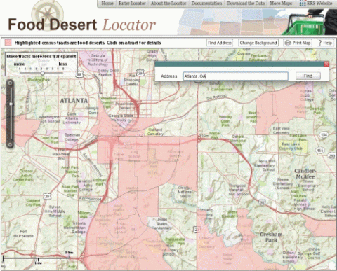
By typing the city, town, or address of interest into the Find Address button, the Food Desert Locator can be used to create maps showing food-desert census tracts for specific communities. The following maps provide examples.

The map above shows food desert census tracts in Atlanta, GA. The pink-shaded census tracts meet the definition of food deserts--low-income sections of Atlanta where a substantial number or share of residents live more than 1 mile from a supermarket or large grocery store. The map shows several food desert tracts south of the downtown area.

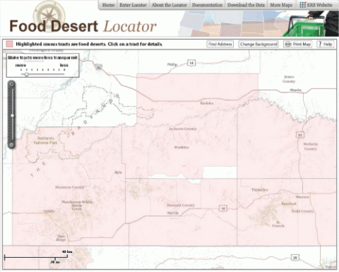
In rural areas, low-income tracts with a significant number or share of residents more than 10 miles from a supermarket or large grocery store are food deserts. Food desert tracts in southwestern South Dakota include sections of the Pine Ridge and Rosebud Indian Reservations.

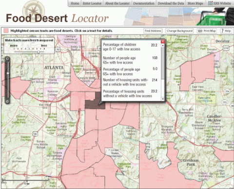
Users can view and download statistics on selected population characteristics of food desert census tracts--such as the number and percentage of children under age 18, seniors age 65 and older, people with low incomes, and housing units without a vehicle--from the Food Desert Locator. For example, looking at the Atlanta map (above) and clicking on one of the food desert tracts indicates that over 200 households, or 23 percent of households in the tract, are over 1 mile from a supermarket and do not own a vehicle.
This article is drawn from:
- Food Access Research Atlas. (n.d.). U.S. Department of Agriculture, Economic Research Service.
We’d welcome your feedback!
Would you be willing to answer a few quick questions about your experience?

