

Compare Your Area's Food Environment With the Rest of the Country
The food environment—including the stores and restaurants in a community, food prices at those establishments, and community norms about food and health—affects daily food choices. Over a lifetime, the food environment’s influence on food choices can add up, affecting individuals’ and communities’ health.
The ERS Food Environment Atlas helps shed light on food environments across the United States. With over 90 food environment indicators, the Atlas provides a spatial overview of a community’s ability to access healthy food and its success in doing so. The Atlas enables comparisons of food environments among communities.
What Information Is Included in the Atlas?
The Food Environment Atlas assembles county-level statistics for three broad categories of food environment indicators:
- Food choices—A community’s access to and acquisition of healthy, affordable food, such as household proximity to grocery stores, number of foodstores and restaurants, expenditures on fast foods, food and nutrition assistance program participation, quantities of selected foods eaten, selected food prices, food taxes, and availability of locally produced foods.
- Health and well-being—A community’s success in maintaining healthy diets, including statistics on household food insecurity, diabetes rates, obesity rates, and physical activity levels.
- Community characteristics—Community attributes that might influence the food environment, such as demographics, income levels and poverty rates, metro-nonmetro status, natural amenities, and recreation and fitness centers.
The year and geographic level of the indicators vary to better accommodate data from a variety of sources. Some data are from the last Census of Population in 2000, while others are as recent as 2009. Some are at the county level, while others are at the State or regional level. The most recent county-level data are used whenever possible. Over time, ERS will add indicators to the Atlas and update old ones.
What Can Users Do With the Atlas?
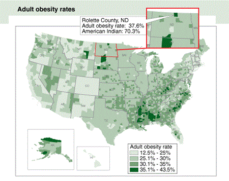
The Atlas allows users to create maps showing the variation in food environment indicators across the United States. For example, the first map shows adult obesity rates across the country, revealing that these rates are highest in the Southeast. Atlas demographic data show that many pockets of high obesity in the West and Midwest also have high percentages of American Indian residents. Clicking on Rolette County, ND, for example, yields a pop-up box showing that in 2007, 38 percent of Rolette’s adults were obese and that in 2008, 70 percent of the county’s residents were American Indian. Clicking on any county produces a pop-up box containing statistics on all 90 indicators for the county.
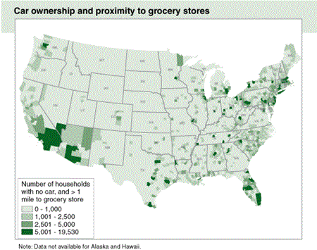
The second map shows county variation in the number of households that may have difficulty accessing healthful, affordable foods because they do not own a car and live more than a mile from a grocery store. The dark green areas of the map denote the 65 counties in 2006 with more than 5,000 such households. Atlas data on metro/nonmetro county designation reveal that in 2000, all of these counties were metro counties. Increases in obesity and diet-related diseases are major public health problems. These trends may be compounded in communities with limited access to affordable, nutritious foods.
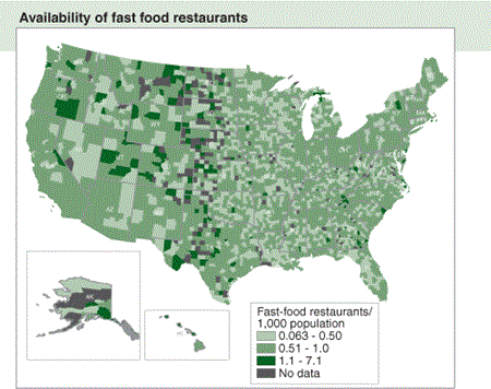
The next map depicts the variation in the number of fast food restaurants per capita across counties, with dark green denoting counties with more than 1 restaurant per 1,000 residents. Low-population counties that host large numbers of tourists or have highway inter-changes tend to have many fast food restaurants per capita. For example, Teton County, WY, just south of Yellowstone National Park, is a prime tourist destination and had 20 fast food restaurants in 2007—slightly more than 1 per 1,000 residents.
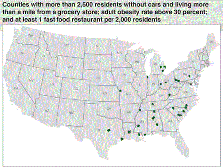
In addition to creating single-indicator maps, the Atlas allows users to create maps identifying counties that share multiple characteristics. The final map identifies 31 counties that share three characteristics:
- More than 2,500 residents without cars and living more than a mile from a grocery store
- Adult obesity rate above 30 percent
- At least 1 fast food restaurant per 2,000 residents
Over 93 percent of the 31 counties with low grocery store access and high adult obesity also had a high number of fast food restaurants per capita.
The variations and associations revealed by the Atlas do not necessarily reveal causal relationships such as whether proximity to grocery stores, density of fast food restaurants, and other access variables contribute to unhealthy weights. Additional research on the complex interactions among food environment factors and health will help identify causal relationships and provide input in developing effective policy interventions.
Food Environment Atlas, by Alana Rhone, USDA, Economic Research Service, April 2024