

Defining the “Rural” in Rural America
Highlights:
-
The share of the U.S. population considered rural ranges from 17 to 49 percent depending on the definition used.
-
Rural definitions can be based on administrative, land-use, or economic concepts, exhibiting considerable variation in socio-economic characteristics and well-being of the measured population.
-
For research projects and economic development programs alike, the appropriate definition of rural will be that which meets the goals of the endeavor.
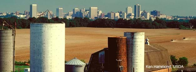
The term “rural” conjures widely shared images of farms, ranches, villages, small towns, and open spaces. Yet, when it comes to distinguishing rural from urban places, researchers and policymakers employ a dizzying array of definitions. The use of multiple definitions reflects the reality that rural and urban are multidimensional concepts, making clear-cut distinctions between the two difficult. Is population density the defining concern, or is it geographic isolation? Is it small population size that makes it necessary to distinguish rural from urban? If so, how small is rural? Because the U.S. is a nation in which so many people live in areas that are not clearly rural or urban, seemingly small changes in the way rural areas are defined can have large impacts on who and what are considered rural.
Researchers and policymakers share the task of choosing appropriately from among the more than two dozen rural definitions currently used by Federal agencies. For example, research on suburban development and its effect on rural real estate prices would probably define rural differently than a study designed to track and explain economic and social changes affecting rural people and places. Programs developed to address the unique problems that small rural governments face will not necessarily target the same rural areas as will programs that are developed to help rural businesses operating in credit-constrained markets. The key is to use a rural-urban definition that best fits the needs of a specific activity, recognizing that any simple dichotomy hides a complex rural-urban continuum, with very gentle gradations from one level to the next.
Delineating a precise line between rural and urban America that best serves the purpose, given the complexity of today’s settlement patterns, involves answering two questions:
- Is a given urban entity defined in terms of its administrative boundaries, its land-use patterns, or its economic influence?
- What is the minimum population size for an entity to be considered urban?
By identifying urban areas first, rural is defined as the territory that is not included. Good decisionmaking in choosing an appropriate rural definition requires an understanding of the key characteristics of urban entities and how they, in turn, determine the characteristics of rural definitions derived from them.
Challenge Number One: Choosing an Appropriate Urban Boundary
There are three different concepts of “urban” that lead to very different boundary definitions, and thus to very different rural definitions:
- The administrative concept, used by many USDA rural development programs, defines urban along municipal or other jurisdictional boundaries.
- The land-use concept, used by the Census Bureau, identifies urban areas based on how densely settled the area is—the picture of settlement you get from an airplane.
- The economic concept, used in most rural research applications, recognizes the influence of cities on labor, trade, and media markets that extend well beyond densely settled cores to include broader “commuting areas.”
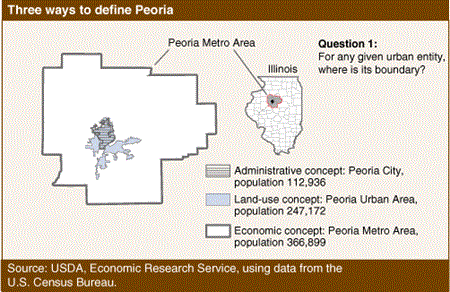
These three concepts represent progressively expansive urban boundaries that differ considerably from one another. For instance, in 2000, Peoria, IL, as defined by its municipal boundaries, encompassed an area with about 113,000 people but as an economic entity it included nearly 367,000 people. Applying a land-use concept resulted in an area with a population between these two alternatives.
For rural development programs that provide assistance to or through local governments, an administrative definition of rural is often a starting point for determining program eligibility. On the other hand, infrastructure programs meant to overcome the disadvantages sparsely populated areas face in providing water and sewer services may find rural definitions derived from the land-use concept helpful in targeting assistance. For programs requiring the coordination of efforts within broader market areas, such as area-wide transportation planning assistance, a definition based on economic concepts may be more appropriate. So ubiquitous are county-level data that researchers often divide urban and rural areas along county lines, making “nonmetro” the de facto economic definition of rural for most research purposes (see box below, "How Are the Boundaries Between Rural and Urban Developed?").
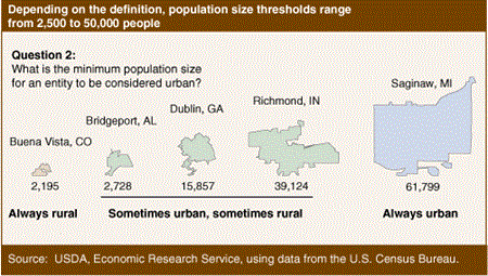
Challenge Number Two: Choosing a Population Size Threshold
In addition to being defined as the area outside urban boundaries—determined in different ways depending on the concept—rural includes some set of towns and villages below a chosen population threshold. For the 1910 Census, rural meant open countryside and any place with fewer than 2,500 people. Though the Census Bureau modified its definition over the decades to keep up with suburban expansion, it did not change the 2,500 population threshold as the minimum size for urban places. Over the same period, thresholds for some USDA rural development programs were adjusted upward, arguably an appropriate response to rapid urbanization. For example, the Rural Housing Program began in 1949, serving communities with fewer than 2,500 people, but it now sets eligibility at less than 20,000 people.
Proponents of a higher threshold point out that towns of 2,500 people typically have not maintained the levels and diversity of employment, goods, and services that existed in 1910. The tremendous transportation and communication advances of the past 100 years helped reorganize economic and social activities around larger towns and cities. The debate over an appropriate population size threshold between rural and urban places is ongoing. Definitions used by Federal agencies use population-size thresholds ranging from 2,500 to 50,000 people. For instance, the definition of rural used for USDA’s Community Facilities programs consists of territory outside Census places of 20,000 or more. In contrast, the definition of nonmetro areas used by most researchers applies a 50,000 population threshold.
Different Definitions Mean Big Differences in Rural Populations
Depending on the boundary choice and the population threshold, the share of the U.S. population defined as rural and its socioeconomic characteristics vary substantially. In 2000, 21 percent of the U.S. population was designated rural using the Census Bureau’s land-use definition (outside urban areas of 2,500 or more people), compared with 17 percent for economically based nonmetro areas (outside metro areas of 50,000 or more).
However, alternative definitions increase that range from 7 to 49 percent. Raising the population size threshold for the land-use definition from 2,500 to 50,000 increases the rural population from 21 to 32 percent. Lowering the threshold for the economic definition from 50,000 to 10,000 decreases the rural population from 17 to 7 percent.
Holding the population threshold constant at the minimum level of 2,500 people but moving from an administrative to a land-use definition drops the U.S. rural population by a third, from 31 to 21 percent. This change represents a shift in the designation of people who live in areas typically described as suburban, who are counted as rural under the narrower administrative concept but as urban under the land-use version. A similar shift in suburban population occurs at the upper population threshold of 50,000, where rural population decreases from 32 percent based on the Census Bureau’s land-use concept to 17 percent under the economic definition. (For descriptions of each definition, see box below, "How Are the Boundaries Between Rural and Urban Developed?")
| Definition | U.S. total | Census Bureau places (administrative) with populations less than 2,500 | Census Bureau places (administrative) with populations less than 20,000 | Census Bureau urban areas (land-use) with populations less than 2,500 | Census Bureau urban areas (land-use) with populations less than 50,000 | OMB micro and metro areas (economic) with populations less than 10,000 | OMB micro and metro areas (economic) with populations less than 50,000 |
|---|---|---|---|---|---|---|---|
| Population, 2000 (millions) | 281.0 | 87.7 | 138.5 | 59.1 | 89.5 | 19.9 | 48.8 |
| Percent of population defined as rural | NA | 31.1 | 49.2 | 21.0 | 31.8 | 7.1 | 17.4 |
| Percent with a college degree | 30.7 | 26.8 | 28.3 | 22.5 | 22.9 | 18.5 | 20.8 |
| Average household income ($1,000) | 57.0 | 56.0 | 56.0 | 51.0 | 49.0 | 40.0 | 43.0 |
| NA = not applicable. Source: USDA, Economic Research Service using data from the U.S. Census Bureau’s 2000 decennial census. |
|||||||
Alternating the definition of rural also varies the socioeconomic characteristics of designated areas. Rural populations consistently show lower education and income levels than the overall U.S. population, however they are defined. Given that rural definitions based on administrative boundaries include larger shares of what could be classed as suburban areas, the education and income levels of their populations are closer to those of the general U.S. population. The suburban population counted as rural is much smaller for the economic definition represented by nonmetro areas. Thus, the share of the rural population with a college degree drops from 28 to 18 percent across this range and the average household income drops from $56,000 to $40,000.
Multiple Measures of Rural Serve Multiple Purposes
Rural definitions are not limited to the options discussed here. For instance, ERS provides an alternative to OMB’s metro and micro definitions that uses census tracts instead of counties (see box below, "What Are the RUCA Codes?"). In the 2002 farm bill, administrative and land-use concepts were essentially combined for a rural definition adopted by several USDA funding programs. Eligible territory includes areas outside Census places of 50,000 or more and their adjacent urban areas.
With so many options, which definition is best? The choice of a rural definition should be based on the purpose of the activity. For instance, analyzing the effect of population loss on per capita fiscal costs for rural communities is best approached using administrative boundaries because taxation and service provision often follow these lines. Tracking urbanization and its influence on farmland prices is best approached from a land-use definition that can distinguish built-up territory from surrounding, less developed land and the degree to which this boundary shifts over time. Mapping discontinuities in the supply and demand for medical services and analyzing their effect on rural well-being would likely focus on distance to labor markets as a key determinant of health care accessibility.
In any application involving measurement, data availability will play a major role. Studies of the effects of unemployment, poverty, retirement, industrial restructuring, and other trends on rural areas cannot easily employ administrative or land-use definitions because data are not available to support them. County-level, economic definitions (nonmetro areas) dominate rural research for this reason. However, researchers need to carefully analyze and report the implications of any definitional choice: Who is included in the study and who is left out? What information is being masked by using large geographical building blocks, such as counties? How does this rural geography vary by State?
Policymakers face the same questions when crafting eligibility rules that best fit particular rural programs but are not as limited by data considerations. Considerable flexibility exists in tailoring definitions to suit a given application, and the appropriate choice may vary depending on program goals. A program providing housing assistance may be designed to target more isolated or economically distressed rural settings than would programs designed to stimulate business starts and job creation. Rural communities lacking access to health services may not be the same areas missing broadband support. Careful consideration of alternative definitions of rural and their socioeconomic characteristics has the potential to improve the overall efficiency of economic development programs by enabling them to better target the intended beneficiaries.
How Are the Boundaries Between Rural and Urban Developed?
Rural definitions based on the administrative concept start with the Census Bureau’s list of “places.” Most places listed in the 2000 Census are incorporated entities with legally prescribed boundaries (e.g., Peoria City), but some are locally recognized, unincorporated communities. Rural is defined as territory outside these place boundaries, together with places smaller than a selected population threshold. For example, USDA’s Telecom Hardship Loan Program defines rural as any area outside Census places of 5,000 or more people.
Rural definitions based on the land-use concept most often start with the Census Bureau’s set of urban areas, consisting of densely settled territory. Rural as defined by the Census Bureau includes open countryside and settlements with fewer than 2,500 residents. Urban areas are specifically designed to capture densely settled territory regardless of where municipal boundaries are drawn. They include adjacent suburbs that are outside place boundaries and exclude any territory within places that does not meet the density criteria.
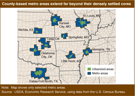
The most widely used rural definition based on the economic concept consists of the 2,050 nonmetropolitan (nonmetro) counties lying outside metro boundaries. Metropolitan (metro) areas are county-based entities that account for the economic influence of cities. The Office of Management and Budget (OMB) defines them as:
- Core counties with one or more urban areas of 50,000 people or more, and;
- Outlying counties economically tied to the core counties, as measured by the share of the employed population that commutes to and from core counties.
Using these criteria, urban entities are defined as countywide or multicounty labor market areas extending well beyond their built-up cores.
Prior to 2000, the land-use concept (Census urban areas) and the economic concept (OMB metro areas) were not applied to urban entities below 50,000 people. In 2000, the Census Bureau added urban areas ranging in size from 2,500 to 49,999 (labeling them urban clusters to distinguish them from the larger urbanized areas that had been defined since 1950). OMB added a new micropolitan (micro) area classification, using the same criteria as used for metro areas but lowering the threshold to 10,000 people. These modifications greatly increase the flexibility of researchers and administrators to tailor rural definitions to different target populations.
What Are the RUCA Codes?
Counties are often too large, especially in Western States, to accurately represent labor market areas in all cases. Thus, metro and micro areas often include territory that is legitimately rural from both a land-use and economic perspective. ERS Rural-Urban Commuting Area (RUCA) codes provide an alternative, economic classification using census tracts rather than counties. Although relatively new, these codes have been widely adopted for both research and policy, especially in rural health applications.
RUCA codes follow (as closely as possible) the same concepts and criteria used to define metro and micro areas. By using the more detailed census tracts, they provide a different geographic pattern of settlement classification. While counties are generally too large to delineate labor market areas below the 10,000 population threshold, RUCA codes identify such areas for towns with populations as small as 2,500. Additional information and files containing the codes are available here.
Rural Definitions, USDA, Economic Research Service, August 2019
Rural Classifications, by Austin Sanders and John Cromartie, USDA, Economic Research Service, March 2024
Land Use, Land Value & Tenure, by Scott Callahan, USDA, Economic Research Service, September 2023